The National Aerospace Laboratory’s (NLR) research aircraft has investigated the volcanic ash cloud hovering over the Netherlands. The purpose of this flight was to verify the accuracy of atmospheric models currently being used to predict the movements of the ash cloud. Â From the flight undertaken by the Cessna Citation on Sunday night above the Netherlands’ southern provinces, it emerged that the ash cloud is highly visible. The edges of the ash cloud hovering above the country’s southern provinces were also highly visible, which is crucial information for pilots when the air space is (temporarily) opened.
The objective of this flight was to verify the accuracy of the models the Royal Netherlands Meteorological Institute (KNMI) uses to calculate the movements of the volcanic ash cloud. These measurements are then used by the Dutch aviation authorities to take decisions regarding the closing and (re)opening of air space.
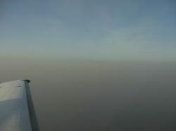
Sunday night’s flight revealed that the models had accurately estimated the location of the volcanic ash layer. The NLR’s research aircraft flew over the ash cloud, which at the time was hovering at a height of 3 kilometres and was comprised of varying thicknesses.
There are very few methods currently available in Europe for precisely measuring and tracking volcanic ash. Moreover, there are no set regulations in place for determining which ash particle concentration levels necessitate the opening (or closing) of air space. NLR researchers are therefore currently working closely with other institutes, including the Royal Netherlands Meteorological Institute, the National Institute for Public Health and the Environment, the Dutch Ministry of Defence, the Ministry of Transport, Public Works and Water Management, and Eurocontrol. This joint research will determine the best methods for quickly and safely launching sensors and measuring instruments capable of accurately monitoring volcanic ash.
Picture: The Cessna Citation nearby the ash cloud

